Next RPC Meeting: Tuesday, April 22, 2025
Direct Link to Live Video (2 PM Central) April 22, 2025
Current Agenda: Agenda
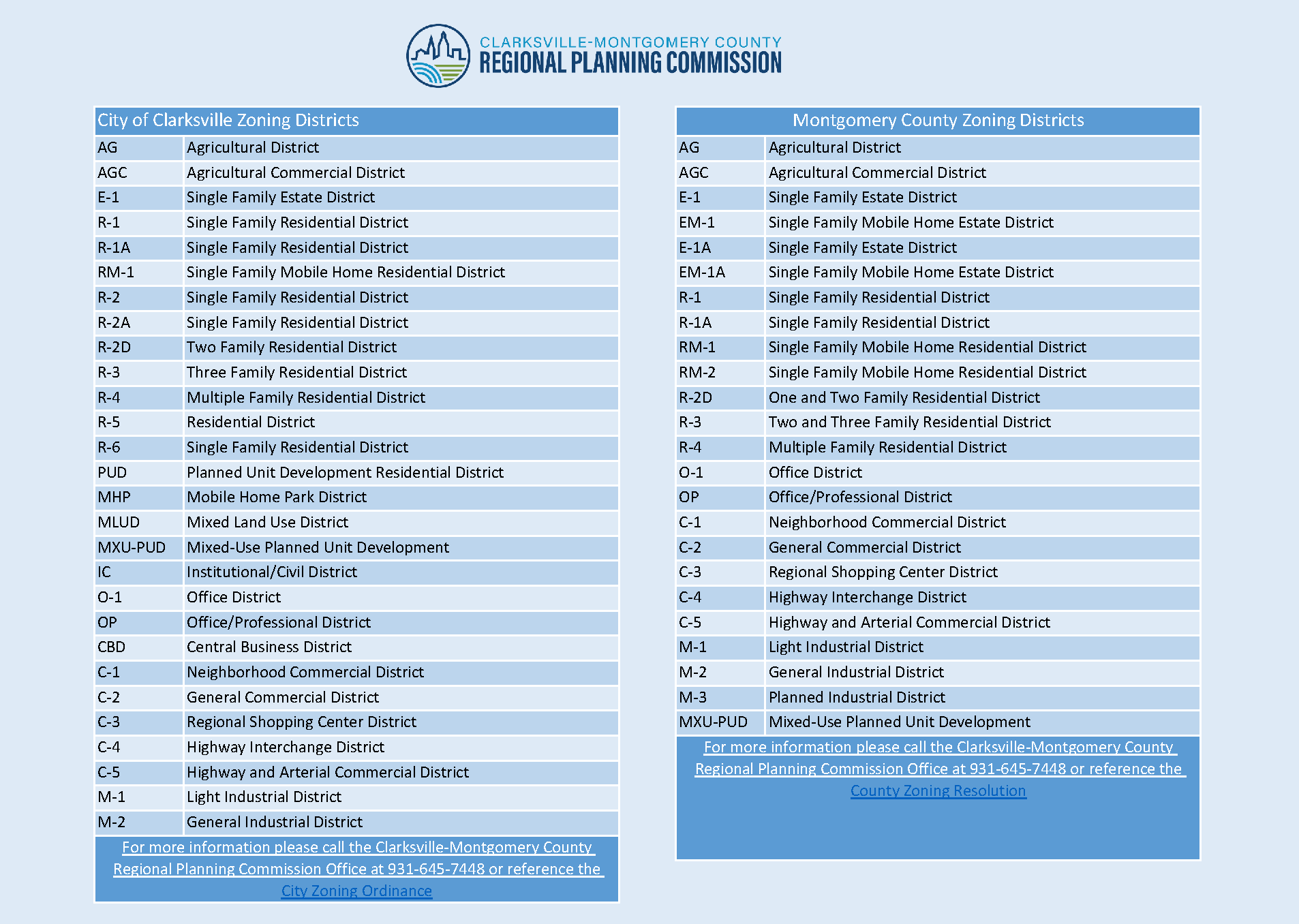
Zoning Cases
| Case # | Map | General Location | Rezoning Request |
|---|---|---|---|
| Z-08-2025 |
A parcel located at the southeast corner of Hillsboro Rd. & Binks Dr. |
R-1A to R-2A | |
| Z-13-2025 |
The northeast corner of the Tiny Town Rd. & Tobacco Rd. intersection. |
R-1A to C-5 | |
| Z-18-2025 | Property that fronts on the South frontage of Dover Road, 200 +/- feet East of the Dover Road and Walker Circle Intersection. | R-1 to C-5 | |
| Z-20-2025 |
South of Tiny Town Road |
R-2/R-4/C-1 to C-5 | |
| CZ-04-2025 |
Approximately 975 feet +/- southwest of the Caps Road and Indian Mound Road Intersection. |
E-1 to EM-1 | |
| CZ-05-2025 |
A portion of a tract 200 +/- feet southeast of the Guthrie Hwy. & Oakland Rd intersection |
AG to C-4 | |
| CZ-06-2025 |
South of Dover Road |
AG to R-1 | |
| CZ-07-2025 |
A tract of land west of the Hampton Station Rd. & Webb Rd. intersection. |
AG to M-2 | |
| CZ-08-2025 |
Two parcels fronting on the east frontage of Harper Rd. 1,250 +/- feet south of the Highway 41-A South & Harper Rd intersection. |
R-1 to R-1A | |
| ZO-4-2025 |
*DEFERRED*
|
||
| ZO-6-2025 |
Additions to Chapter 11 regarding enforcement of the zoning ordinance and penalties. |
Subdivisions
Maps and Plats are preliminary and subject to change before the Planning Commission meeting.
| Case # | Map | Plat | Name |
|---|---|---|---|
| S-11-2025 | Gold Landing | ||
| S-24-2025 | *DEFERRED*
Jackson Hills Section 2 (Cluster) |
||
| V-05-2025 | *DEFERRED*
Variance for Jackson Hills Section 2 (Cluster) |
||
| S-25-2025 | *DEFERRED*
Preliminary Plat North Rossview Commons Lots 1-9 |
||
| S-26-2025 | Katherine Sharp Property Lots 1 & 2 Mcadoo Creek Road | ||
| S-27-2025 | Rose Hill Section B Lots 42-48 & 51-59 |
Site Plans
Maps and Plans are preliminary and subject to change before the Planning Commission meeting.
| Case # | Map | Plan | Name |
|---|---|---|---|
| SR-12-2025 | *WITHDRAWN*
Johnson Self Storage |
||
| SR-17-2025 | The Joseph | ||
| SR-20-2025 | Dollar General | ||
| SR-27-2025 | Ace Hardware | ||
| SR-28-2025 | Silverstone Condos | ||
| SR-29-2025 | Woodland Trace | ||
| SR-30-2025 | Tucker Antiques | ||
| SR-32-2025 | Titan Storage | ||
| SR-33-2025 | LG Electronics Tennessee Phase II | ||
| LA-03-2025 | *WITHDRAWN*
Landscape Appeal for Tucker Antiques |
Annexations
No current annexations
Common Design Review Board (April 21, 2025)
Current Agenda
| Case # | Map/Plan | Location |
|---|---|---|
| DDR-1-2025 | 517 Madison St. |
Previous Month’s Zoning Cases (March)
| Case # | Map | General Location | Rezoning Request |
|---|---|---|---|
| Z-03-2025 |
A property fronting north of West Bound I-24 right of way and south of Tylertown Rd, approximately 760 +/- feet east of Trenton Rd and Tylertown Rd Intersection and across from Roscommon Way. |
C-4 to C-2 | |
| Z-07-2025 | N of W Concord Drive | R-2 to R-4 | |
| Z-09-2025 | South of Slayden Circle | R-1 to R-2A | |
| Z-10-2025 | A parcel fronting on the south frontage of Tiny Town Rd., South of the Tiny Town Rd. & Pembroke Rd. intersection. | R-1A to C-2 | |
| Z-16-2025 | East of Old Russellville Pike, North of Stone Container Drive | M-3 to C-5 | |
| Z-17-2025 | Property fronts on the East frontage of Fantasy Lane, 325 +/- feet North of the Fantasy Lane & Candlewood Court Intersection. | R-1 to R-3 |